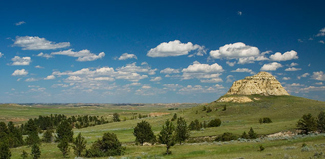
NORTHEAST MONTANA… EXPLORING NEW TERRITORY
by Rick and Susie Graetz
Following Hwy 87 north from Fort Benton through Havre to Canada, one travels the western boundary of what is perhaps the most magnificent prairie country in the nation. The US Canadian line, the 49th parallel of latitude, defines this wondrous territory on the north. The southern demarcation is a bit jagged; staying on the southern fringe of the Missouri River Breaks to US Hwy 91, it then abruptly points south a bit before turning east to trace the "Lonesome Highway 200" to North Dakota which delineates the eastern boundary.
A distinct region unto itself, this place of the Great Plains harbors unique landforms. Grand scenes intermingle with smaller bits of geologic wonder. Space, much of it undisturbed, is its greatest commodity and an unending sky delivers a feeling of no borders or confinement where a human can stretch and breathe.
At first, the openness, the immensity and the distances may seem overpowering. Gradually, though, you get comfortable with it all; then you notice the beauty and splendor. Not just the imposing structures, but also the abundance of simple grandeur … and the soft fusion of earth and sky on horizon that seems endless.
In both its liquid and frozen form, water shaped the physical geography in this territory. Ice sheets advancing out of Canada slid into northern Montana from the east edge of the Blackfeet Reservation by Glacier National Park, across to North Dakota. These natural bulldozers gouged and scraped the land, carrying and pushing rocks and soils. They "borrowed" boulders, called glacial erratics - some as large as a cars - from northern Saskatchewan and Manitoba, Canada, more than 500 miles away, and presented them to northern Montana on permanent loan. Thousands of these gifts are scattered across the prairie.
As the glaciers scoured the landscape, they tamed it and laid down rich soils of glacial till in the areas that grow wheat and barley, especially the far northeast corner of this region. Land south of the Missouri escaped the ice and has much coarser topography and poorer soils.
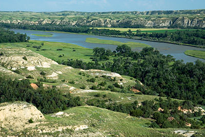
Crowning hills and defining roads, the red, pink and sometimes yellow rocks, in the eastern reaches of Montana, add color to the landscape. It is difficult not to notice them, they are the only hard rocks found in these parts. Many folks mistakenly call them scoria, but scoria is a volcanic rock mostly in the form of basalt and is usually black. Clinker is the proper name, and while clinker comes from heat, it is not volcanic in origin.
A geologist investigating the blend of surface and underlying rocks near historic Fort Union and the confluence of the Missouri and Yellowstone rivers named this particular combination the Fort Union Formation. For the most part, it is made up of mudstones, sandstones and shales dominated by clay - all sediments - and coal reserves. These rocks are weak and easily eroded, perhaps explaining why much of the terrain is somewhat subdued.
So how did clinker come about? The eastern part of Montana was once under the waters of an inland sea. Over time, organic matter was deposited and compressed, forming a layer of coal. Eventually, the sea evaporated and as the surface of the land transformed, coal veins that were raised above the valley bottoms dried out. Prairie wildfires, ignited by lightning, set many of the coal seams on fire. For centuries they smoldered until the coal in the particular area ran out, usually when the fire reached the other side of the hill. Much like the kiln method used to make pottery and bricks, the fiery coal baked or cooked the rocks above it, and in the process, altered the color and hardness of the rocks.
Prairie wildfires, ignited by lightning, set many of the coal seams on fire. For centuries they smoldered until the coal in the particular area ran out, usually when the fire reached the other side of the hill.
Dave Alt, longtime professor of geology at the University of Montana, and co-author of Roadside Geology of Montana says, “These rocks had the misfortune of being above a coal seam." But perhaps they weren't unfortunate, had the rocks not hardened, they would have been washed away through the process of erosion. Now, the clinker proudly brightens and props up the hills of eastern Montana and shields roads from gumbo.
What is “gumbo?” Again, the Fort Union Formation is at fault. The sediments of this arrangement have a great deal of expandable clay in them, especially the shale – this particular type is called Bearpaw shale. All shales hold water and get very sticky and greasy when wet. It doesn’t take much precipitation to create literally impassable situations on roads not covered with pavement, a heavy dose of gravel or clinker. Traction is impossible. Vehicles slide in whatever direction the wet mess decides to take them, get bogged down in ever-deepening ruts or the gumbo buildup on the tires halts all motion. Walking isn’t any easier. If you are wearing boots with lug soles, you will gain height rapidly, all the while slipping and siding. The cure for a bad case of gumbo is good old sunshine and a dry wind.
Outlaws, Natives, Mountains and “Deserts”
The northeast/north central region of our state is where Montana’s earliest known history was played out. Millions of bison migrated through the territory and nomadic Plains Indians followed them. The shaggy beasts sustained these great Indian Nations by providing food, clothing and shelter. As the white invaders moved in, the bison were slaughtered and the natives eventually were forced to ever shrinking reservations.
On the sunrise side of the Bear Paw Mountains and stretching into the island range of the Little Rocky Mountains lays the Fort Belknap Indian Reservation. These 737,714 acres are the domain of 5,000 Assiniboine and Gros Ventre Indians. The Gros Ventre live along the mountains in the Hays - Lodgepole area, while the Assiniboine have settled at Fort Belknap Agency along the Milk River to the north.
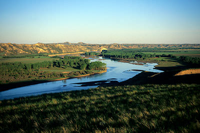
Farther along US Highway 2, beginning on the east side of Fort Peck Lake extending down the Missouri River towards Culbertson, is the Fort Peck Indian Reservation. This tract encompasses over 2,093,318 acres - making it the second largest Montana reservation - and provides a home for more than 6,800 Assiniboine and Sioux.
Though mountains are scarce in this country, a dominant range makes its presence known. Indians migrating through the territory north of the Missouri River called them “the island mountains.” From a distance, the Little Rockies, a 50-square mile mass of igneous and sedimentary rock, resemble atolls rising from the prairie sea of North Central Montana. Although not very lofty (the highest point is 5,720-foot Antoine Butte), they reach 2,500 feet above the surrounding plains and can be seen from 75 miles away.
Much of early-day Montana deserves the description the Wild West, but the Little Rocky Mountains and the country rolling south into the Missouri Breaks was perhaps the epitome of the Old West etched on movie screens. A little over 100 years ago, the characters of those times ... cattle barons, gold seekers, outlaws, cowboys, vigilantes, rustlers and horse thieves went about their way here. And before being forced off the land, the free-roaming Plains Indians camped in the shadow of these mountains.
In 1893, Pike Landusky discovered gold in a canyon near the site of the town named after him. At about the same time, gold was also found to the northeast in Ruby Gulch. Here, Pete Zortman established a mill to extract the precious metal from the ore. The town that grew up below the bonanza took on his name.
One of the Little Rockies most written about happenings involved a bar room killing. Pike Landusky, himself a legend, met his end at the hand of Harvey “Kid” Curry, one of the wild Curry Brothers Gang, who frequented the Little Rockies. The stories vary, but the shooting supposedly took place in 1894 during a Christmas celebration in Jew Jake’s Saloon. This event started Kid Curry on the outlaw trail as he joined up with the likes of Butch Cassidy and the Sundance Kid. A hideout in the badlands south of the mountains kept them safe from “the long arm of the law.”
The only other mountains of sorts out here are far less commanding. In the northeast division, the Little and Big Sheep mountains are a series of hills and eroded badlands south of Circle. They have the loftiest summit in these parts at 3,625 feet, but rise no more than 300 feet above the adjacent country. A high point just off of the North Dakota line between Sidney and Glendive is 800 feet higher than the remote prairie it overlooks. At a whopping 3,084 feet in elevation, Blue Mountain holds the distinction of having the greatest relief in northeastern Montana.
Northeast Montana’s centerpiece is the Missouri River. As a route of western expansion it had few equals and became Montana’s lifeline. The river holds forth in an incredible landscape. Breaks, heading toward the river from both the north and south, are rough terrain cut by water - a labyrinth of coulees, gullies and canyons between high ridges. Some of the ridges are void of trees while others grow in an open forest, usually of ponderosa pine.
French trappers working the lower segments of the Missouri and Yellowstone rivers well before Lewis and Clark came through called the dry land formations they encountered “les mauvais terres” (badlands). Painter Karl Bodmer, who accompanied German Prince Maximillian on the Missouri in 1833, was captivated by these unusual landforms and included them in his paintings.
These mini-deserts begin forming once the vegetation cover has been destroyed, usually by wildfire or overgrazing. Water running off of the underlying clay surface and soft bedrock causes erosion. Gullies are formed and seeds of potential new growth of plants and grasses are washed away or unable to take hold in the hardened soil. Heavy spring and summer downpours accelerate the process. Steeper slopes are etched more quickly, and seemingly smooth surfaced alluvial deposits fan out below them. Soon, the entire disrupted area is void of green growth. Once well into the creation stage, they perpetuate themselves and usually become permanent. While this carved, dry-appearing country receives as much precipitation as adjacent areas, the lack of a protective shield of flora gives it an image of receiving very little moisture.
Exquisite sandstone formations are often intermingled with a badlands environment. Miniature and giant toadstools, fine lined domes, balancing rocks, and sentinel-like spires add color and personality to these rain-furrowed hills while statue-like gremlins and goblins stand watch atop high cliffs. Wind erosion helps fashion them, taking away one grain of sand at a time.
The Crown Jewel of the Nation's Wildlife Refuge System
The stretch of the Missouri River from the Fred Robinson Bridge to Fort Peck is a showcase of sandstone creatures and badlands that illustrates evidence of what passed here 70 million years ago. Sections of McCone, Garfield and Phillips counties north and south of the Missouri were home to Tyrannosaurus Rex, Triceratops, Albertosaurus, Mosasaurus (a marine reptile) and other giant creatures. Due to erosion, some of the richest records of prehistoric life in the world have been, and continue to be, uncovered here. In 1902, one of the first T-Rex fossils ever found was discovered near Jordan in the Hell Creek badlands.
Home to much of this dinosaur burial ground is the Charles M. Russell National Wildlife Refuge. The western edge of the CMR, as it is commonly referred to, cohabitates with the last ten miles of the eastern end of the Upper Missouri River Breaks National Monument. From this over lapping section, a canoe will cover 150 miles by the time it reaches the spillway of Fort Peck Dam and the eastern perimeter of the refuge.
The CMR occupies a large swath of Montana's northeast quadrant and is in the core of some of the least inhabited country in the United States. The 1.1 million-acre refuge straddles part of the free flowing Missouri River and takes in the rugged Missouri Breaks, wild prairie grasslands and the 250,000-acre Fort Peck Lake with its 1,600 miles of shoreline.
A landscape--for the most part unchanged since the Corps of Discovery went up against the river’s current in the spring of 1805--that elevates the quality of the float. Sit on a bank amidst this quiet country and imagine all that passed by over the past two centuries … we like to call it “time and the river flowing.”
It's an uncommon land ... at once stark, beautiful, imposing and inviting, this Charles M. Russell National Wildlife Refuge. Time has left most of the remarkable landscape with the same appearance as when the indigenous peoples hunted and did battle here. And while some of the wildlife species have disappeared, notably bison and grizzly bears, other animals, including elk and bighorn sheep are coming back strong.
The mix of landforms of the CMR is impressive. Table-topped uplands give way to rugged ravines, wide and precipitous canyons (some 1,000 feet deep) and spectacular badlands. This much-dissected expanse of ground has been broken by flows of water, such as Seven Blackfeet Creek, Devils Creek, Snow Creek, Hell Creek, the Musselshell River and many smaller, more intermittent creeks.
Elevations and relief are low by Montana standards, but when looking up at some of the high points from the bottom of a gulch, the slopes appear as tough to climb as any mountain. When Fort Peck Lake is at full pool, the lowest elevation on the refuge is 2,246 feet. One of the loftiest spots is 3,241 feet on a divide just above the east side of Seven Blackfeet Creek, close to the center of the CMR.
Enormous expanses of mostly public land (more than two million acres) managed by the Bureau of Land Management surround the Charles M. Russell refuge. Primitive roads cross this BLM land and lead to the CMR. Unlike most of the refuge, this outlying terrain is predominantly rolling prairie broken by shallow coulees and occasional buttes. Drainages that make up the river breaks of the CMR get their start in small draws and deeper gulches of this higher ground beyond the preserve.
Bowdoin and Medicine Lake National Wildlife Refuges
Bowdoin National Wildlife Refuge, seven miles east of Malta, is part of a once incredibly rich animal kingdom frequented by the plains tribes, including the Blackfeet, Cree, Gros Ventres and the Assiniboine nations. They hunted and gathered roots, berries and herbs here. Tipi rings found on the refuge are evidence of their passing.
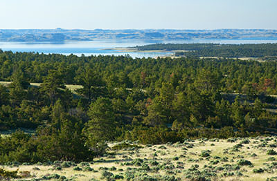
Good management has created one of the best nature viewing areas in Montana. More than 230 different species of birds and waterfowl have been identified here. Bowdoin is also considered Montana’s prime place to see pronghorn antelope in their natural habitat. Big game hunting is not allowed so the herd has natural age distribution; big animals are evident.
Bowdoin’s upland native grasses are considered to be of extremely high quality as evidenced by the presence of the Sprague’s Pipit and the Baird’s Sparrow; birds known to choose only the best habitat.
White pelicans return each spring to nest and raise their young on Bowdoin’s Pelican Islands. Some of us who float prairie waterways call these birds “the river’s Air Force.” With their enormous black-tipped wingspans, they silently fly in “military-like” formation and perform “bombing” missions.
Larger animals especially need adequate cover and they find it here in the form of shelterbelts made up of tall grasses, shrubs and cattails. These protected areas also provide food for the many birds and mammals that remain throughout the cold months.
The names of all the neighbors who reside here throughout the warm days are too numerous to mention. Included though in the population are double-crested cormorants, whitetail deer, great blue herons, ring-necked pheasants, sandpipers, sharp-tailed grouse, coyotes, osprey, an occasional bald eagle, all sorts of hawks and falcons, numerous ducks, tundra swan, loons, owls, the yellow-rump warbler and the yellow-billed cuckoo.
From the time the “transient inhabitants” arrive for the summer until they gather in autumn to begin their southern sojourn, constant chatter fills the air; there is much to do and “talk” about as new life is created.
Early morning and late afternoon in the spring and fall are the best times to visit the refuge. Its 15,500 acres can be seen via a 15-mile circular route. This special natural community is easily reached from Malta.
The previous weeks witnessed a raucous homecoming ... a tradition carried out each year as tens of thousands of geese, ducks and birds fill the spring sky on their way back to Medicine Lake. This prairie oasis, bordered by seemingly endless stretches of wheat fields witnesses one of the great wildlife spectacles in America.
Medicine Lake National Wildlife Refuge is another gem. And early spring is a delightful time to explore it. Mid-May, at about 5:00 a.m., the lifting fog, a product of a cold night, catches the first light of a mellow sunrise ... the tall grass and reeds take on a gold and orange hue while the surrounding water gathers all the colors of the sky transforming its surface into a pastel painting. The crisp air is noisy, as the entire neighborhood chats in profusion. Grouse, performing their mating ritual, add a distinct sound of to the excitement. The previous weeks witnessed a raucous homecoming ... a tradition carried out each year as tens of thousands of geese, ducks and birds fill the spring sky on their way back to Medicine Lake. This prairie oasis, bordered by seemingly endless stretches of wheat fields witnesses one of the great wildlife spectacles in America.
Just 22 miles south of Plentywood, Medicine Lake NWR is in part, located above the former channel of the Missouri River. Before the last ice age, the river ran north to Hudson Bay. A glacier moving out of Canada forced the waterway to turn south. When the massive flow of ice receded, it left a blanket of glacial till, resulting in rocky, rolling hills interspersed with numerous wetlands, marshes and ponds.
Medicine Lake is the largest of these bodies of water and depends upon summer thunderstorms, winter snowmelt, the flow of Big Muddy Creek reaching the area from the north, and Lake Creek coming from the northeast for its water. The name is derived from medicinal herbs and roots Indians gathered around its shores. An exploration of the surrounding higher terrain shows teepee rings and other signs of early-day use.
More than 100,000 migrating waterfowl make Medicine Lake their warm weather habitat. Great blue herons, white pelicans, geese, grebes, and ten different species of ducks share this prairie ecosystem with countless other birds. Each year, as many as 30,000 ducklings are produced, and every fall, more than 10,000 sandhill cranes spend a week here. Foxes, raccoons, pheasants and deer also populate the area.
The refuge boasts the largest pelican rookery in Montana and third largest in the nation. These magnificent birds nest on the big island in the middle of Medicine Lake. More than 2,000 white pelicans are born each season.
The piping plover, a rare bird, actively breeds in the wetlands. Their flute-like call is one of the great sounds of nature.
Geese are the first to arrive; showing up in February and March, they set up their territory and prepare for nesting even before the ice melts. It's usually late April before Medicine Lake thaws, just in time for the summer dwellers to arrive. All the winged creatures leave by around the first of November when the lake begins to freeze. Coulees that drain towards the lake offer shelter for the animals that stay throughout the long cold months. Winter at Medicine Lake is quiet, as ice and snow dominate the landscape and temperatures can plummet to 50 degrees below zero.
As you tour the refuge, you’ll note some cultivated areas. Farmers plant grain fields on several hundred acres each spring. The refuge keeps about one-quarter of the potential harvest and then lets it stand as a wildlife food source. This practice helps to keep birds and animals out of the local fields.
Although wildlife is there throughout the summer, May, June and October are the best months to see Medicine Lake. July and August can get quite hot. Montana’s warmest temperature on record was documented here when the thermometer reached 117 degrees on July 5, 1937.
Management of this Northeast Montana treasure is entrusted to the good hands of the US Fish and Wildlife Service.
People and Communities
There are fewer people in Northeast and North Central Montana than anywhere else in the state, and space dwarfs this human presence whether it is well apart from neighbors on farms and ranches, or in towns. Evidence of the era of the first sodbusters is plentiful. Old buildings that once housed these settlers and their dreams still stand, only to serve as refuges for small animals, birds and owls.
A look at some of the communities out here shows the colorful human side of a place often referred to as Missouri River Country. These enclaves aren’t new but rather have evolved from the solid “stock” who struggled through the drought that halted the homestead era, the tough winters and a roller coaster agricultural climate. Today, the citizens of these communities are the backbone of the Montana prairie country.
These descendants of sodbusters and products of cattle outfits that have been in the same family for generations provide the region with a sense of permanency and independence. A strong profile dictated by rural life and past experiences characterizes the folk who call the plains home.
Towns are the essence of this territory where the natural features capture attention. Social and commercial activities interact within them in a way that is all but disappearing across America. Cafes, hardware and grocery stores are where stockmen, farmers, implement dealers and bankers meet to discuss ag-economics, their families, and the weather. You’ll still find drug stores with soda fountains and chances are that you can walk in the door of any business and shake the hand of the owner. A genuine welcoming atmosphere prevails.
The people of these isolated havens that dot the sprawling prairie deal with them and never give up. A “can do” attitude holds sway over town meetings or at the supper table as residents look for answers and new possibilities. Hope always seems to be there.
Yet population loss is the rule throughout most of this stretch of Montana. Examples are the Garfield and Petroleum county areas. Garfield lost 20 percent from 1990 to 2000 and Petroleum lost 5 percent in the same period. Together they have 1,772 people. As of February 2003, Garfield County had 1,279 people and 82,326 head of sheep and cattle, a 64-to-1 ratio. Some places though, especially the bigger communities like Sidney and Glasgow, are holding their own.
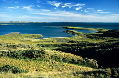
Every town has its own personality and history... Hinsdale, Saco, Wolf Point, Poplar, Culbertson, Bainville, Circle, they are not places just to pass through, each adds to the lure of the prairie.
Connecting with the Country Around Jordan
Late 1800’s photographer L. A. Huffman called it "The Big Open," National Geographic termed it "Jordan Country" and others refer to the sparsely populated landscape south of Fort Peck Lake as “The Big Dry." The small ranching town of Jordan is the heart of this scenic territory.
Rising from the banks of Big Dry Creek and straddling MT Hwy 200, Jordan was founded in about 1896 by Arthur Jordan. He asked that the town take the name of a friend from Miles City who was also named Jordan. The first residence was Arthur Jordan's tent. Later, he established a post office and store for this fledgling cow town.
Jordan and the surrounding expanse of rangeland is still very much cowboy country and the place retains an old west flavor. False-front buildings on main street haven’t changed much since the communities earliest days ... some are over 80 years old.
This seat of Garfield County is an entry to some of the most remote and beautiful mix of deep river canyons, badlands and prairie wilderness in the west.
From Jordan, drive east on MT 200 toward Circle. Fifteen miles out, you'll enter a ten-mile stretch of very spectacular views of red and yellow colored buttes, badlands and distant vistas. Farther yet, 36 miles from town, you’ll encounter Hwy 24 pointing north, which parallels the Dry Arm section and eastern edge of Fort Peck Lake. If you'd like to camp, put a boat in the water, or just see the lake, take advantage of the recreation areas along its length; there are several and they are well marked. The Sand Arroyo badlands found here are fascinating. Remember, most of the roads to these places are only passable when it is dry. Getting hung up in the gumbo created by wet weather is not a pleasant surprise.
Hell Creek State Park, on Fort Peck Lake, 26 miles north of Jordan is a popular area. On the way there you'll go through the stately piney buttes and high rises on the road that offer excellent views of some of the upper reaches of the Missouri Breaks and the CMR Refuge. Devil's Creek, Snow Creek and Crooked Creek, all north of Jordan, are worthwhile places to explore. The Haxby Road east of Jordan reaches a long way out through the badlands and into the Breaks. All of these places will amaze you ... they are truly uncommon and part of the most fantastic prairie wilderness regions of America.
The Milk River Valley, From Malta to Glasgow to Fort Peck
US Highway 191 climbs a steep grade out of the Missouri River bottoms north of Fred Robinson Bridge. As it gains the upper extent of the river breaks, a far-reaching, high plains landscape sprawls towards Canada 125 miles to the north. The Little Rockies rise directly ahead and a rough, rolling prairie flows off to the east. You’re heading through historic landscape, once the domain of the Plains tribes, toward the valley of the Milk River and the ranching and farming community of Malta.
Between 1870 and 1900, this was the setting for the true “Old West” and Malta might well be considered its capital. Trappers, cattlemen, cowboys, and all manners of outlaws wandered through here. Cattle drives up from Texas brought the herds to winter on the region’s rich grasslands between the Missouri and Canada. It was once the focal point of a vast beef empire and was founded to serve the area ranches. Big cow outfits held sway; names like Phillips, Coburn, Matador and Phelps are all etched in Montana’s history.
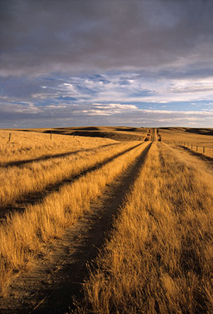
Indians called the future town site “The Big Bend” as the Milk River turns in a half-circle near here. The first “citizen” was Robert M. Trafton out of Minnesota, who came to collect the bleached bones of slaughtered bison.
In 1885, Trafton established a trading post a few miles to the west of what would eventually become the seat of Phillips County. The westward moving Great Northern Railroad reached Siding 54 on August 13, 1887, and Trafton moved his store to the site in anticipation of increased business. Cowboys and other solitary souls inhabiting these high plains of North Central Montana needed a Saturday night destination; Siding 54, the 54th rail siding west of Minot, ND, became that place … and it was as wild as any western movie could depict!
The newly minted community needed a proper name. Railroad agents gathering in Minneapolis blindfolded an employee and with a spin of the globe determined the town’s name. Stopping the motion, his finger came to rest on Malta, an island in the Mediterranean Sea. Thus Siding 54 was named Malta. Many other eastern Montana railway towns such as Glasgow, Zurich, Harlem and Hinsdale owe their titles to this unimaginative process.
Back roads leading north of town to Loring, a small picturesque community six miles from the port of Morgan and the Canadian border, pass through scenic river breaks of Little Cottonwood and Cottonwood creeks as well as segments of the Milk River bottoms.
On May 8, 1805, the first “tourists” to this region, the Lewis and Clark Expedition, camped at the confluence of the Milk and Missouri rivers, about 18 miles southeast of present-day Glasgow. Lewis explored the Milk for about three miles and wrote, “The water of this river possessed a peculiar whiteness, being about the colour of a cup of tea admixture of a tablespoon full of milk. From the colour of its water, we called it Milk River.”
In the Milk River Valley, the town of Glasgow (named for Glasgow, Scotland) came to be in 1887 as the Great Northern Railroad was pushing its way west. It was originally called Siding 45 and four or five tents made up the first structures.
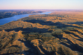
Originating as a place for the railroad to pick up livestock and grain, Glasgow remained a quiet agricultural community for an extended period. In the fall of 1933, its lifestyle changed abruptly as men, desperate for work, jammed into the town to help build Fort Peck Dam. In 1933 during the Great Depression, President Franklin Delano Roosevelt approved the construction of Fort Peck Dam to control flooding and more importantly to create jobs; 10,500 people found jobs on the endeavor. Completed in 1940, at the time, the undertaking was the nation’s largest public works project. Fort Peck Dam is one of the biggest earth-filled river impediments in the world.
Used as the primary trade and transport depot for the dam project, Glasgow was on its way to becoming one of the busiest places in Northeast Montana. While most of the workers lived in and around the construction area, many stayed in Glasgow. Estimates are that there were 50,000 people in the area during the construction peak.
Adding immensely to local prosperity and growth was the arrival of the Glasgow Air Force Base in the late 1950s; its closure in 1969 was a huge financial blow to the town. While the base existed, almost 16,000 people lived between it and Glasgow. Today, this town of 3,500 people is a regional livestock center and a gateway to the eastern end of the CMR and Fort Peck Lake.
Leaving Glasgow, it’s roughly 18 miles to Fort Peck Lake. With almost 1,600 miles of shoreline, it is by far the largest body of water in Montana.
With the commencement of the dam project, the orderly development of the Fort Peck town site, planned and built by the Army Corps of Engineers to house its employees, began in the fall of 1933. A neat and tidy community, it invites you to stay in the 1930-style Fort Peck Hotel (the rooms were remodeled in 1993), and if you’re there between June and September, be sure to attend the Fort Peck Summer Theatre. Constructed in 1934 as a movie house for the dam workers, it was kept open 24 hours a day to entertain the round the clock work shifts.
Fort Peck Lake is treasured for its size and outdoor opportunities. Six recreation areas within a few miles of the dam provide access. The Montana Governor’s Cup Walleye Fishing Tournament is a nationally recognized event held the second weekend in July.
Northeast Montana and the people of Fort Peck boast of the new 17,500-square-foot Fort Peck Interpretive Center and Museum. With the main theme as the Missouri River, dinosaur and wildlife exhibits, fossils and history abound. An aquarium containing the different species of fish living in the river and Fort Peck Lake is a highlight. Interpretive displays and programs on the wildlife of the adjacent 1.1 million-acre Charles M. Russell National Wildlife Refuge are also a feature.
The star of the museum is "Peck's Rex,” a Tyrannosaurus Rex skeleton standing in all his glory. It is similar to those uncovered just south of Fort Peck and in the Hell Creek formation.
East of the Museum and north of Hwy 24, the Milk River Observation Point is easily accessed. On May 8, 1805, Clark ascended to the top of these hills just south of the confluence of the Milk and the Missouri to view the landscape and work on his map.
The Lewis & Clark Overlook, on the south side of Hwy 24, opens a viewshed that extends out over Fort Peck Lake and the terrain the Corps moved through. An exhibit interprets the Milk River, the importance of cottonwoods to the Expedition, and profiles the Assiniboine Indians that populated this region.


